Ideas & Insights

Thoughts, trends, and innovations in Intelligent Transportation Systems.

1Tenor LiDAR Solution for Traffic Monitoring

LiDAR Technology: A New Era in Traffic and Road Monitoring

Have you heard of LiDAR?
If you’re not yet using this technology in your ITS (Intelligent Transportation Systems) projects, it’s time to rethink your strategy.

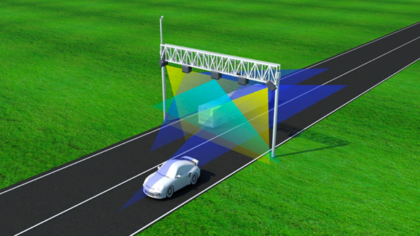
LiDAR (Light Detection and Ranging) is the kind of innovation that makes any ITS professional’s eyes light up. We’re talking about sensors capable of seeing what cameras and inductive loops can’t — with centimeter-level accuracy, 24/7, rain or shine.

Why is LiDAR the future of ITS?

  • 🚗 Real-time traffic monitoring with reliable 3D data.
  • 📊 Vehicle classification by axle count, size, and volume — with no physical contact.
  • 🎯 Advanced applications for average speed monitoring and lane management.

The best part? Installation is fast, modular, and maintenance is minimal. In other words: efficiency, cost-effectiveness, and scalability.

Use cases that are already changing the game:

  • Weigh-in-Motion with cutting-edge accuracy.
  • Road safety through irregular behavior detection.
  • Real-time management of corridors and dedicated lanes.
  • And even rail and port applications!

This isn’t hype. It’s reality.

LiDAR is already widely used in countries like Germany, China, and the U.S., and is now gaining momentum in Brazil. Combined with AI and robust detection algorithms, it delivers valuable data that turns infrastructure into intelligence.

Want to understand how this could apply to your project?
I’m helping companies implement high-performance LiDAR solutions across Brazil. I’m confident your project can benefit from this technology!

📅 Let’s schedule a quick chat — just send me a message.

The future of mobility is being mapped in 3D. And it starts now!


Unlocking the Power of LiDAR in Smart Cities

As cities worldwide embrace digital transformation, innovative technologies are playing a crucial role in reshaping urban mobility. Among them, LiDAR (Light Detection and Ranging) stands out as a game-changer, offering unparalleled precision in mapping, monitoring, and optimizing city infrastructure.

What is LiDAR?

LiDAR is a remote sensing technology that uses laser pulses to measure distances and create high-resolution 3D maps of the environment. By emitting laser beams and analyzing their reflection times, LiDAR generates detailed spatial data, making it an invaluable tool for smart cities.

How LiDAR Enhances Urban Mobility

The integration of LiDAR in urban environments brings numerous benefits to transportation and city planning:

🚦 Traffic Flow Optimization

LiDAR can monitor vehicle and pedestrian movements in real time, helping city planners optimize traffic signals, reduce congestion, and improve road safety.

🚌 Public Transportation Efficiency

Smart bus stops and transit systems equipped with LiDAR can analyze passenger flow, predict demand, and improve scheduling, leading to better service and reduced wait times.

🚶 Pedestrian and Cyclist Safety

LiDAR helps identify high-risk areas for pedestrians and cyclists, allowing city officials to implement targeted safety measures such as better crosswalk designs and dedicated bike lanes.

🏗️ Infrastructure Monitoring

Continuous LiDAR scanning can assess the structural health of bridges, roads, and tunnels, enabling predictive maintenance and preventing costly repairs or accidents.

The Future of LiDAR in Smart Cities

As urban populations grow, the need for intelligent infrastructure becomes more pressing. With advancements in LiDAR technology and the decreasing cost of deployment, more cities are integrating LiDAR into their smart city initiatives. From enhancing mobility solutions to improving overall urban planning, LiDAR is paving the way for safer, more efficient, and more sustainable cities.

By harnessing the power of LiDAR, smart cities can move beyond traditional urban management and embrace data-driven decision-making, ultimately improving the quality of life for all residents. The future of urban mobility is bright—and LiDAR is lighting the way.